Cheap flights are available to Nimes airport, 1:15 hours from our place, Avignon
or Montpellier 1:40h or Lyon 3:00h.
From Montpellier or Avignon head for Nimes, then take the N106 north to Ales.
From Lyon follow direction A7 or Valence (in absence of other directions, the A7
south for Marseille). Take the A7 south to exit
19 and follow signs for Pont St Esprit and then Bagnoles sur Ceze or Ales. From Bagnoles
s. Ceze take the D6 to Ales.
You will arrive on the ring-road to the east of Ales, you should head north (right) following signs for Aubenas.
From Ales follow signs for Aubenas (D904) until after a few kilometers you'll
see signs for Genolhac. This is just after you've gone over a hill (with lovely
rock strata), Aubenas is off to the right but you go straight on to Genolhac. Follow the D906 for about 25km
as it heads up into the hills and passes through Le Pradel and Portes - with a big castle on the hill above.
About 4km after Portes there is a sharp left turn in the small village of
Les Tavernoles (the D52) signposted for La Begude, St Andeol de Clerguemort
and several other places. If you end up down in Chamborigaud then you've
missed the D52.
Once on the D52, drive for about 7km passing La Baraque (a goat fromargerie)
before you see a single auberge (large stone building) on the left - approx. 1km
after the fromargerie. There
is a small left turn here signposted "Mas De Tourette" (3.4km),
"La Boire" as well as "Voie Romaine" (Roman Road). There's
also a small DFCI sign indicating two water basins one at Sambuget in
3.5 KM - we live just below the Sambuget water tank.
Take this road and always choose the uphill direction if there are any small
roads heading left down into the valley. Follow this road for 3.5 Km. It's probably best described as a paved track,
so take it easy. After about 3.4 Km you'll see a sign saying you're entering
the Parc National Des Cevennes, just after is a sign saying you're entering
Sambuget - this isn't a big place so slow right down. You'll pass a small
track heading sharply down to the left and 3 or 4 houses below, then a house on the left hand side of the road and just after that is the back
of a sign which is the sign for Sambuget if you're coming from the opposite
direction. On the right is a cleared area, a hard to see water tank and some
new trees. Almost immediately is an old tree stump on the left and a small
track leading down to it. That's us.
If you're driving down, e.g. from the UK, you will probably want to head for the
A71, which is the motorway down the center of France and becomes the A75 after
Clermont Ferrand. You can also take the A20 down the west of France and then
head across. Your target is Mende which is about 20km along the N88 from
junction 39 on the A75.
From Mende take the N106 to Florac (also signposted Ales) (or if you have time
head down the D986 to St Enimie, which is the gateway to the nothern part of the
Gorges Du Tarn and follow the Tarn upstream to Florac).
The easiest route is to then continue on the N106 from Florac which will be signposted Ales. Follow this for about 37km, passing through Col de Jalcreste and St Privas de Vallongue until just before Colle De Deze you will see a sign for St Andeol de Clerguemort, the C3 on your left. (If you enter Collet De Deze then you've gone too far) Take the C3 and follow it for 10km to our place. It's a single track road so take it easy.
You will pass through the hamlets of Le Tour and Font Bonne and after about 4km the road splits. Take the right fork which is actually signposted St Andeol and Sambuget (handwritten local sign). Keep following signs for St Andeol, pass a few more houses, through a small pine plantation, across a small river and up the valley. The road then starts to climb, passing between a couple of houses (Pre Neuf), it bears right, heads up and just after a house on the right there is a sharp right turn. Its signposted Sambuget, follow that around, past the hamlet of Lezenier, and you'll enter into the Parc National - only 1km to go. From here you climb 2 or 3 hairpins, ignore a right turn to 'Sambuget Bas' continue uphill and you'll meet a road coming from the right (just next to 2 rubbish bins) -it's signposted Sambuget - take the right and we are 300m down the road on the right.
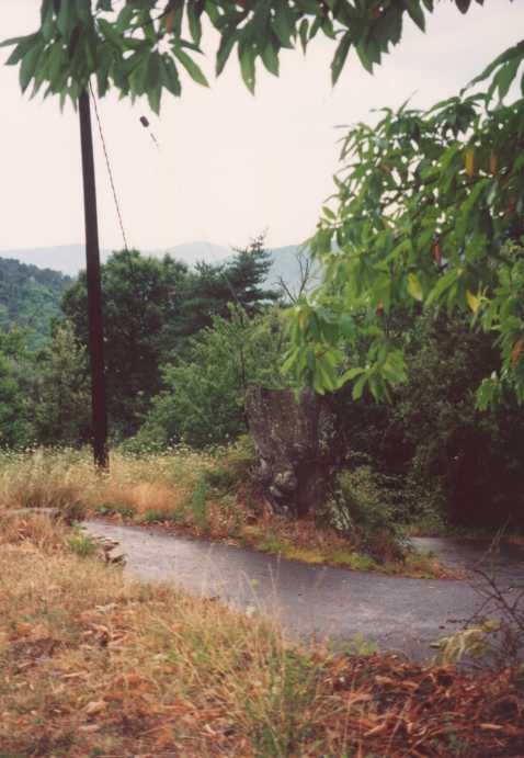
You will see a large tree stump on the right of the road (set back a little)
(A
photo). Go just past it and then swing off the road down to the tree stump
where the drive begins.
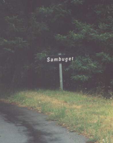
If you see a sign indicating you are entering Sambuget (A
photo), then you missed the tree stump, back up about 20 meters and try
again.
Turn of the road, cross a small patch of grass, onto the paved bit around the
tree stump and follow the drive across the orchard until you get to the garage.
Park here - the house is down to the right - follow the steps down, under the
vine and round to the side where the big green door is the front entrance.
An alternative route from Ales
If you have trouble finding the Aubenas road out of Ales, or you're starting in the center of Ales, then an alternative route is to then follow the N106 from Ales which will be signposted Mende (and occasionally Florac). Follow this for about 25km until just after Colle De Deze. As you exit Collet de Deze on the N106 you will see a sign for St Andeol de Clerguemort, the C3 on your right. Take this road and follow it for 10km to our place. It's a single track road so take it easy.
You will pass through the hamlets of Le Tour and Font Bonne and after about 4km the road splits. Take the right fork which is actually signposted St Andeol and Sambuget (handwritten local sign). Keep following signs for St Andeol, pass a few more houses, through a small pine plantation, across a small river and up the valley. The road then starts to climb, passing between a couple of houses (Pre Neuf), it bears right, heads up and just after a house on the right there is a sharp right turn. Its signposted Sambuget, follow that around, past the hamlet of Lezenier, and you'll enter into the Parc National - only 1km to go. From here you climb 2 or 3 hairpins, ignore a right turn to 'Sambuget Bas' continue uphill and you'll meet a road coming from the right (just next to 2 rubbish bins) -it's signposted Sambuget - take the right and we are 300m down the road on the right.
You will see a large tree stump on the right of the road (set back a little)
(A
photo). Go just past it and then swing off the road down to the tree stump
where the drive begins.
If you see a sign indicating you are entering Sambuget (A
photo), then you missed the tree stump, back up about 20 meters and try
again.
Turn off the road, cross a small patch of grass, onto the paved bit around the
tree stump and follow the drive across the orchard until you get to the garage.
Park here - the house is down to the right - follow the steps down, under the
vine and round to the side where the big green door is the front entrance.
An alternative route from Florac
From Florac, cross the river and turn left on the N106 towards Mende and then just after
turn right onto the D998 to Le Pont De Montvert. There is a campsite on the
corner of this junction. Wind up the valley following the D998 until you get to
Pont De Montvert - a lovely medieval town on the Tarn river - then
continue up the D998 for about 8km until you see signs for the D52 off to the
right at Col de la Croix de Berthel. The D52 will be signposted "Le Tronc,
Figerolle, St Andeol de Clergemort" and possibly others. Follow the D52 as
it winds over the ridge (Col de la Baraquette) for about 12km until you pass the
Col de Banette.
After the Col, look for a sign for "Destourbe" and a small road heading downhill to the right (very sharp)
which will have several signs including one for a horse riding center and a
campsite. You will have passed a couple of turns to the right signposted St
Andeol, ignore these. The turning is just before the hamlet of 'Destoube'. If you miss this turn, don't worry, carry on along the D52 for about 3
km and look out for a sharp right at the auberge - large building on right of
road. If you end up here, follow the directions above.
Assuming you spotted the turn, follow this road down a series of zigzags,
past a few houses and a small church, down another hairpin and then through the
chestnut trees to a junction where there are 2 rubbish
bins. Go straight on - it should be signposted with a small
sign to Sambuget. About 300m after this fork you will see a large tree stump on
the right of the road (set back a little) (A
photo). Go just past it and then swing off the road down to the tree stump
where the drive begins.
![]()