Vom Flughafen/Anfahrt uebers Rhonetal
[Anmerkung: Aus Gruenden die Euch bestimmt schnell klar werden, wenn Ihr einmal
den Weg zu unserem haus in Sambuget gefunden hat, schlagen wir vor Ihr plant
unbedingt vor Einbruch der Dunkelheit in Sambuget anzukommen]
Billige Fluege gibts oft nach Nimes (1:15 Stunden entfernt),
Avignon oder Montpellier (1:40Std.) or Lyon (3 Std.).
Von Montpellier oder Avignon fahrt Ihr Richtung Nimes, dann auf der N106
Richtung Norden nach Ales.
Von Lyon auf der A432/A46 Richtung A7 oder Valence. Auf der A7 Richtung Sueden
bis zur Ausfahrt 19 , dann den Hinweisschildern zuerst nach Pont St Esprit, dann
nach Bagnoles sur Ceze folgen. Von Bagnoles s. Ceze auf der D6 nach Ales.
In ales Ales der Beschilderung nach Aubenas (D904) folgen, bis nach ein paar
Kilometern Schilder fuer die D906 Richtung Genolhac zu sehen sind. Auf der D92
ungefaehr 25km fahren, in die Huegel und durch Le Pradel und Chateau de
Portes - mit einem grosssen Schloss auf der anhoehe ueber der Strasse. Ca. 4km
nach Chateau de Portes biegt die Strasse (D52) in dem kleinen Dorf Les
Travernoles scharf nach links ab. Die abbiegung ist ausgeschildert mit La Begude, St Andeol de Clerguemort
und anderen Ortschaften. wenn Ihr in Chamborigaud landet, habt Ihr die
Abzweigung zur D52 leider verpasst.
Auf der D52 fahrt Ihr ca. 7km vorbei an La Baraque (mit einer Ziegenkaeserei)
und kommt (ca. 1km nach den Ziegen) schliesslich zu einem grossen Steingebaeude
zu Eurer Linken. Eine kleine Abzweigung nach links ist mit "Mas De Tourette" (3.4km),
"La Boire" und "Voie Romaine" (Roemerstrasse) ausgeschildert.
Ein kleines Schild des DFCI weist auf 2 Wasserbecken (bassin) hin, eines davon
ist das in Sambuget (3.5 km) - wir wohnen unterhalb des Sambuget Beckens.
Bigt dort also links ab, und praktisch sofort danach gleich wieder rechts
and der Weggabelung (bergauf), und folgt der "Strasse", die eigentlich
eher ein Pfad ist (Vorsicht, langsam!) ca. 3.5 km. Nach ca. 3.4 km kommt ein
Schild, "Parc National Des Cevennes", und gleich danach das Ortsschild
fuer Sambuget - gleich bremsbereit halten, denn jetzt kommt ein enger Pfad der
scharf nach links in Richtung einiger Haeuser unterhalb der Strasse abzweigt.
Nicht abbiegen, sondern weiter vorbei an einem Haus zur Linken. Gleich danach
ist links die Hinterseite des Ortsschilds von Sambuget (fuer Leute die aus der
anderen Richtung kommen) zu sehen. Rechts ist eine Lichtung, das etwas
versteckte Wasserbecken, ein paar neu angepflanzte Baeume und dann ein alter Baumstumpf
links, von dem ein Pfad abgeht. Das ist unsere Einfahrt!
Hier abbiegen, uber ein Fleckchen Gras auf den geteerten Weg neben dem
Baumstumpf und durch die Obstbaeume bis zur Garage und parken. Das haus ist
unten links, einfach den Steinstufen folgen, unter dem wilden Wein durch am Haus
entlang, um die Ecke - et voila - die gruene Eingangstuer!
Driving down the center of France
[Note: we strongly advise to plan on arriving at our place well before dark -
you'll know why once you have managed to find it!]
If you're driving down, e.g. from the UK, you will probably want to head for
the A71, which is the motorway down the center of France and becomes the A75
after Clermont Ferrand. You can also take the A20 down the west of France
and then head across. Your target is Mende which is about 20km along the
N88 from junction 39 on the A75.
From Mende take the N106 to Florac (or if you have time head down the D986
to St Enimie, which is the gateway to the nothern part of the Gorges Du Tarn
and follow the Tarn upstream to Florac).
From Florac, take the D998 to Le Pont De Montvert (a lovely medieval town
on the Tarn river) then continue up the D998 for about 8km until you see
signs for the D35 off to the right at Col de la Croix de Berthel. The D35
will be signposted "Le Tronc, Figerolle, St Andeol de Clergemort" and possibly
others. Follow the D35 as it winds over the ridge (Col de la Baraquette)
for about 12km until you pass the Col de Banette.
After the Col, look for a small road heading downhill to the right (very
sharp) which will have several signs including one for a horse riding center
and a campsite. If you miss this turn, don't worry, carry on along the D35 for
about 3 km and look out for a sharp right at the auberge - large building on right of
road. If you end up here, follow the directions above.
Assuming you spotted the turn, follow this road down a series of gentle
zigzags and at the first fork go left (uphill) - it should be signposted
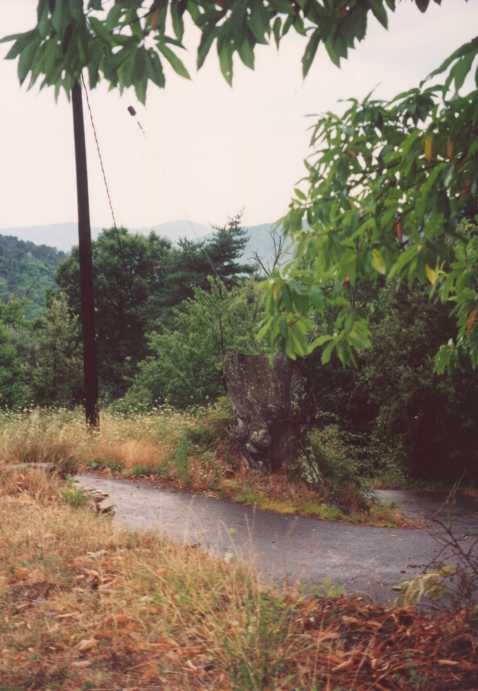
with a small sign to Sambuget. About 1km after this fork you will see a large
tree stump on the right of the road (set back a little) (A
photo). Go just past it and then swing off the road down to the tree stump where the drive begins.
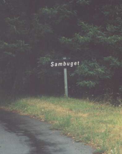
If you see a sign indicating you are entering Sambuget (A
photo), then you missed the
tree stump, back up about 20 meters and try again.
Turn of the road, cross a small patch of grass, onto the paved bit around
the tree stump and follow the drive across the orchard until you get to the
garage. Park here - the house is down to the right - follow the steps down,
under the vine and round to the side where the big green door is the front
entrance.
